Tour Zu Fuß The Municipal District of Bandon – Kinsale - Courtmacsherry Loop - Photo

Tous les sentiers balisés d’Europe GUIDE+

© OpenStreetMap contributors
Länge
Länge
5,2 km
Maximale Höhe
Maximale Höhe
57 m
Positive Höhendifferenz
83 m
Km-Effort
Km-Effort  
6,3 km
Min. Höhe
Min. Höhe
0 m
Negative Höhendifferenz
83 m
Boucle
Boucle
Ja
Kennzeichnung
Kennzeichnung
Erstellungsdatum :
2025-02-06 12:59:42.544
Letzte Änderung :
2025-02-06 12:59:42.544

(0 Nachricht)

Zu Fuß
Zu Fuß
1h25
Schwierigkeit : Einfach

Scannen Sie diesen QR-Code, um die Tour in der SityTrail-Anwendung zu öffnen

Kostenlosegpshiking-Anwendung

Logo SityTrail SityTrail

IGN / Geografische Institute

SityTrail aus dem App Store herunterladen SityTrail von Google Play herunterladen

Logo SityTrail SityTrail World

Die Welt öffnet sich für Sie

SityTrail aus dem App Store herunterladen SityTrail von Google Play herunterladen SityTrail auf Huawei AppGallery herunterladen

Über SityTrail

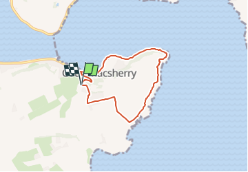
Tour Zu Fuß von 5,2 km verfügbar auf Unbekannt, County Cork, The Municipal District of Bandon – Kinsale. Diese Tour wird von SityTrail - itinéraires balisés pédestres vorgeschlagen.

Höhenprofil

Foto-Galerie

Ort

Land:
Ireland
Region :
Unbekannt
Abteilung/Provinz :
County Cork
Kommune :
The Municipal District of Bandon – Kinsale
Standort:
Courtmacsherry
Gehen Sie:(UTM)
520454 ; 5720083 (29U) N.

Touren in der Umgebung

Tour Auto The Municipal District of Bandon – Kinsale - Kinsale - Sheeps’head - WAW part 1 - Photo
Auto
Bernard Lejeune

Auto

Sehr leicht
The Municipal District of Bandon – Kinsale, Unbekannt, County Cork, Ireland
256 km | 297 km-effort
Unbekannt
Nein


Schließen
Meine Abonnements